Nine Pensacola areas from Downtown to Cordova Park: ZIP codes, zoned high schools and typical home values, from city plans, school zones and Zillow.
Last checked Oct. 11, 2026. Sources: the City of Pensacola’s 2025 Urban Core, Westside and Eastside redevelopment plans and its zoning and CRA maps, Escambia County’s subdivision, address and bus stop layers, Escambia County Public Schools’ Find Your School lookup, the Florida Department of Education’s 2026 school grades, Zillow Research, the Census Bureau’s QuickFacts and OpenStreetMap.
Pensacola is a city of 54,011 people, according to the Census Bureau’s 2023 American Community Survey five-year estimates, in Escambia County. Its oldest neighborhoods sit on the bay around downtown and Palafox Street, with the historic districts of Seville, North Hill and Old East Hill close by. Interstate 110 runs north from downtown to I-10, with exits for U.S. 98 (Exit 1), Cervantes Street (Exit 2), Maxwell Street (Exit 3), Fairfield Drive (Exit 4) and Brent Lane and Airport Road (Exit 5). Northeast of downtown, the city extends along Bayou Texar and Scenic Highway toward the airport.
Three things to know before you compare areas:
- The city is not the whole of “Pensacola.” Brent, Ferry Pass, West Pensacola, Warrington and Myrtle Grove are separate Census places in unincorporated Escambia County, though many of their addresses have a Pensacola mailing address. Our your town, county and neighbors page lists them, and every area in this guide is inside the city.
- ZIP codes are big. The Census Bureau counts four ZIP codes, 32501 to 32504, with at least a tenth of their land in the city, and each covers several areas below, so a ZIP code’s home value is a rough guide to any one neighborhood.
- School zones do not follow city limits. Escambia County Public Schools runs every public school in the county, and the school a child attends depends on the street address, not the city. Check any address with the district’s Find Your School lookup.
Moving here? Start with our moving to Pensacola guide.
The nine areas at a glance
| Area | Main ZIP code | Zoned high school | Typical home value in that ZIP, August 2026 | Guide |
|---|---|---|---|---|
| Downtown | 32502 | Pensacola | $336,653 | Downtown |
| Seville | 32502 | Pensacola | $336,653 | Seville |
| North Hill | 32501 | Pensacola | $265,232 | North Hill |
| Belmont-DeVilliers | 32501, 32502 | Pensacola | $265,232 (32501) | Belmont-DeVilliers |
| Westside | 32501, 32502, 32505 | Pensacola | $265,232 (32501) | Westside |
| Eastside | 32503, 32501 | Pensacola | $296,076 (32503) | Eastside |
| East Hill | 32501, 32503 | Pensacola | $265,232 (32501) | East Hill |
| East Pensacola Heights | 32503 | Washington | $296,076 | East Pensacola Heights |
| Cordova Park | 32503 | Washington | $296,076 | Cordova Park |
Home values are the Zillow Home Value Index for the ZIP code, a modeled typical value for the middle third of homes, not a sale price. The citywide figure was $266,727 in August 2026, up 1.2% in a year. Zoned schools come from addresses in each area checked in the district’s Find Your School lookup; Pensacola High and Washington High were both graded C for 2026, and each area’s page has its elementary and middle schools and their grades. More is in our home prices guide and schools guide.
Map
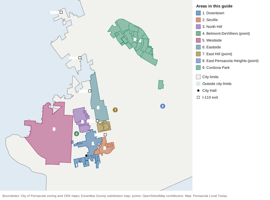
Map: Pensacola Local Today, drawn from City of Pensacola zoning and CRA district boundaries, Escambia County’s subdivision map and place points from © OpenStreetMap contributors. Areas without a published boundary are shown as points.
Downtown
The city’s downtown zoning districts, about 270 acres on both sides of Palafox Street from Wright Street to the bay, including Community Maritime Park and Plaza de Luna. About 950 addresses, four in 10 with a unit number. Zoned for Pensacola High. Read the Downtown guide.
Seville
The 36-block Pensacola Historic District around Seville Square, between Palafox Street and Ninth Avenue south of Chase Street, designated by the city in 1968. About 460 addresses, all in ZIP 32502. Zoned for Pensacola High. Read the Seville guide.
North Hill
The North Hill Preservation District, bounded by Blount, Palafox, Wright and DeVilliers streets, about 170 acres of houses north of downtown with five small parks and squares. All in ZIP 32501. Zoned for Pensacola High. Read the North Hill guide.
Belmont-DeVilliers
The blocks around Belmont and DeVilliers streets, just off North Hill’s southwest corner, which the city’s plan describes as a historic hub for music and entertainment. Henry T. Wyer Park is inside. Zoned for Pensacola High. Read the Belmont-DeVilliers guide.
Westside
The city’s Westside redevelopment district, 1,141 acres west of downtown, from the former Baptist Hospital site through the Tanyard to Main Street, with about 4,350 addresses. The page also covers Sanders Beach, the waterfront neighborhood on its southern edge. Zoned for Pensacola High. Read the Westside guide.
Eastside
The city’s Eastside redevelopment district, 257 acres north of Cervantes Street between Hayne Street and Ninth Avenue, with Hollice T. Williams Park. Mostly in ZIP 32503. Zoned for Pensacola High. Read the Eastside guide.
East Hill
The grid of streets northeast of downtown and north of Cervantes Street, including the Old East Hill Preservation District. Split between ZIP codes 32501 and 32503, with a Publix on its southern edge. Elementary zones vary; zoned for Pensacola High. Read the East Hill guide.
East Pensacola Heights
The neighborhood east of Bayou Texar along Scenic Highway, all in ZIP 32503, with A.K. Suter Elementary, graded A for 2026, inside it. Zoned for Workman Middle and Washington High. Read the East Pensacola Heights guide.
Cordova Park
About 574 acres of recorded Cordova Park plats along Bayou Boulevard, about 1,280 addresses, all in ZIP 32503, about 2 miles by road from the airport. Zoned mostly for Cordova Park Elementary and Washington High. Read the Cordova Park guide.
How we built this
We used only areas that an official plan or map, or OpenStreetMap, names and places:
- The city’s 2025 Community Redevelopment Agency plans. The Urban Core plan lists the established neighborhood associations in and around downtown, including Belmont-DeVilliers, North Hill, Old East Hill, East Hill, Aragon and the Seville Square Historic District, and describes the city’s historic districts and their boundaries. The Westside and Eastside plans describe those districts, and the CRA’s district map gives their boundaries and acreage.
- The city’s zoning map for the historic district zones (Seville, North Hill and Old East Hill) and for the downtown zoning districts.
- Escambia County’s subdivision map for the recorded Cordova Park plats.
- OpenStreetMap, which marks North Hill, East Hill, Cordova Park, East Pensacola Heights and Sanders Beach as named places and was the source for the park and store lists.
Where no boundary is published (East Hill, East Pensacola Heights, Belmont-DeVilliers and Sanders Beach), each page says so and counts the addresses within a stated distance of the mapped point. Address counts and ZIP code shares come from Escambia County’s address layer. We left out areas we could not place on a map with a source, and we do not name individual subdivisions; Aragon, a single development next to Seville, and the Tanyard, which the city names but does not map, are mentioned only on the pages around them. Distances are measured on the road network with the OSRM routing engine, and they are distances, not drive times.
Related: Pensacola population and growth, Escambia County property taxes and getting around.
Frequently asked questions
What are the neighborhoods in Pensacola?
This guide covers nine areas that a city plan, a county map or OpenStreetMap names and places: Downtown, Seville, North Hill, Belmont-DeVilliers, the Westside, the Eastside, East Hill, East Pensacola Heights and Cordova Park.
Which Pensacola ZIP code has the highest home values?
Of the ZIP codes in this guide, 32502 had the highest Zillow Home Value Index in August 2026, $336,653, followed by 32503 at $296,076 and 32501 at $265,232. The citywide figure was $266,727.
Do Pensacola school zones follow city limits?
No. Escambia County Public Schools runs every public school in the county, and the school a child attends depends on the street address, not the city. Most areas in this guide are zoned for Pensacola High; East Pensacola Heights and Cordova Park are zoned for Washington High.
How many people live in Pensacola?
54,011, according to the Census Bureau’s 2023 American Community Survey five-year estimates for the city.
What are Pensacola’s historic districts?
The city’s Urban Core redevelopment plan describes four: the Pensacola Historic District around Seville Square, the North Hill Preservation District, the Old East Hill Preservation District and the Palafox Historic Business District downtown.
Have your say